The construction industry is undergoing a technological revolution driven by innovations that boost efficiency, safety, and sustainability. Automation plays a crucial role in enhancing precision, reducing labor costs, and increasing worker safety by minimizing the need for direct human interaction with hazardous or repetitive tasks. CHCNAV is at the forefront of this transformation with its new MCNAV 3D excavator guidance system, a state-of-the-art solution that brings advanced technology directly to machine operators on job sites worldwide.
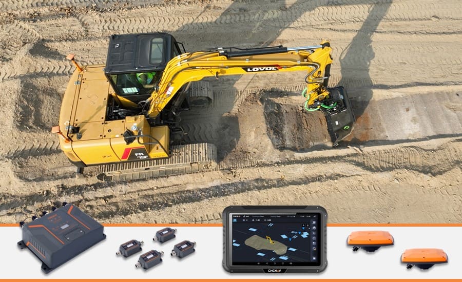
The MCNAV system for excavators combines a high-precision GNSS receiver with rugged IMU sensors to provide operators with accurate, real-time guidance on the position of the excavator's tip relative to project design models. The system's integrated cloud solution ensures site managers have access to up-to-date models at every stage of the project, enabling precise excavation to target surfaces. By making project drawings and models readily available to machine operators, the MCNAV system significantly reduces the reliance on traditional survey methods. This enhanced precision boosts productivity and cost efficiency, allowing projects to be completed faster and more economically.

The MCNAV 3D guidance system for excavators with the high-precision GNSS receiver and rugged IMU sensors.
KEY BENEFITS OF THE MCNAV FOR EXCAVATORS SYSTEM
Improved Accuracy and Precision
The MCNAV system leverages high-precision GNSS technology and advanced IMU sensors to deliver accurate, real-time positioning data, allowing operators to adhere closely to design specifications. This reduces the risk of human error and prevents over-excavation, ensuring correct alignment, depth, and slope. The system’s precision enhances work quality and ensures compliance with increasingly stringent engineering and regulatory standards.
Increased Productivity and Cost Efficiency
The MCNAV system streamlines operations by minimizing the need for manual measurements and adjustments, accelerating the excavation process, and optimizing workflow. The system increases overall efficiency by reducing machine downtime—often unavoidable with traditional surveying techniques—and potentially lowering the number of machines required. The MCNAV system also reduces rework and adjustments, resulting in shorter project schedules, maximized equipment and labor utilization, and significant reductions in material waste and fuel consumption.
Better Sites Management
By integrating with the MCSite cloud service for real-time monitoring and enhanced project documentation, the MCNAV for Excavators system improves site management by minimizing delays and optimizing resource utilization. Site managers and surveyors can ensure that all machines on-site have up-to-date, real-time information on project locations and progress. Seamless integration with other management tools provides project managers with current data on excavation tasks, resource allocation, and operational efficiency.
Enhanced Safety
The MCNAV system significantly enhances safety on excavation sites by providing machine operators with real-time access to as-built drawings, allowing them to identify and avoid hazards such as underground utilities. Automated guidance reduces the need for workers to be in dangerous environments and minimizes the risk of accidents. With less reliance on traditional staking and checking operations, surveyors and other personnel spend less time around active machinery, further reducing the potential for worksite accidents.
MAIN FEATURES OF THE MCNAV FOR EXCAVATORS SYSTEM
Advanced Visualization and Customization
The MCNAV for Excavators system delivers an exceptional 3D viewing experience with high-fidelity CAD drawings, ensuring precision in excavation tasks. Operators can take advantage of customizable views and shortcuts that streamline their workflow, while project progress is vividly displayed in real-time using color-coded maps. Whether working with simple lines or complex 3D models, the MCNAV system is a valuable tool for both large and small worksites. Additionally, the system offers seamless switching between 2D and 3D modes, providing the versatility needed for diverse construction scenarios.
Ease of Use and Cloud Integration
Designed for user-friendliness, the MCNAV for Excavators system features intuitive menus and clear views, making it accessible to both novices and experienced professionals. The system includes a straightforward calibration process that minimizes delays during startup. This ease of use extends to its cloud capabilities; the MCSite cloud platform enables remote access, troubleshooting, and data synchronization, ensuring operators maintain high productivity. Over-the-air (OTA) updates keep the system current with the latest features and improvements.
Exceptional Compatibility
The MCNAV for Excavators system offers extensive compatibility with a wide range of attachments, including tilt rotators from Engcon and Steelwrist, with many popular models available as presets. The system is adaptable and supports various radio protocols, including Satel external radio modules. It also features a built-in global coordinate system library that can be edited and supports numerous design files and drawing formats.

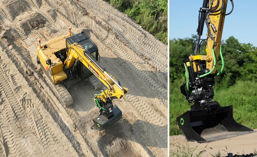
Excavators featuring the advanced MCNAV Excavator 3D Guidance System.
Reliable Hardware
Durability and performance are central to the MCNAV for the excavator system’s hardware design. It includes a high-performance, highly integrated MC300 receiver that is built with industrial-grade reliability. The system’s IS300 IMU sensor is rated IP69K, and the GNSS antennas are IP68-rated with a robust metal bottom shell. The MCNAV system also includes a durable quick-release mechanism for easy tablet removal, ensuring it withstands harsh construction environments while consistently delivering reliable performance. This makes it ideal for worksites where daily removal of the tablet and antennas is necessary, as well as for rental fleets with similar needs.
TRANSFORMING EXCAVATION WITH MCNAV 3D GUIDANCE
The MCNAV 3D Guidance System for Excavators offers advanced precision, increased productivity, and enhanced safety. With its innovative technology, seamless cloud integration, and exceptional compatibility, this next-generation solution from CHCNAV meets the diverse needs of construction projects. Designed for durability and ease of use, the MCNAV system empowers operators and site managers, delivering consistent, high-quality results. As the construction industry evolves, CHCNAV’s commitment to innovation ensures that its solutions remain at the forefront, providing reliable, cost-effective tools for the challenges ahead.
We are thrilled to announce that the MCNAV 3D Guidance System for Excavators will be officially launched this September at a premier event in Tallinn, Estonia. Whether you are in Estonia or not, don't wait until the event to find out more! Interested individuals and dealers from different countries are encouraged to submit their inquiries now for exclusive updates and insights on this cutting-edge technology. Join us in stepping into the future of excavation with the MCNAV systems!
____
About CHCNAV
CHC Navigation (CHCNAV) creates innovative GNSS navigation and positioning solutions to make customers' work more efficient. CHCNAV products and solutions cover multiple industries such as geospatial, construction, agriculture, and marine. With a presence across the globe, distributors in more than 130 countries, and more than 1,900 employees, today, CHC Navigation is recognized as one of the fastest-growing companies in geomatics technologies.


